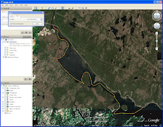
This past weekend, Trent Hardy and I did a two day trip in the Burnside area. The forecast looked good, with a mix of sun and cloud, with winds 15-20knots from the SW. This area is generally sheltered, especially within Long Reach. Depending on where you launch from in Burnside, parking can be an issue. We launched just past the bridge to Squid Island, and parked the car a little further up the road. Its important to not block the wharf or access to the beach for others.We left Burnside at 11am, heading west into Fair and False Bay. Along this route we saw lots of ducks, terns and cormorants. There are lots of cabins in the area, and I can imagine that in the height of summer this could be a busy area, especially in Mishes Cove. We found a lot of mussell beds along the way, and according to some cabin owners they are safe to eat, so its very easy to pick mussells from your kayak when the tide is low. After leaving Mishes cove we headed north into Long Reach. What a beautiful place, with the high lands on either side. On the western side of the reach there is a well defined cove, with an old log cabin and a small stream running. This is where we camped for the night. I must note that the beach dissappears almost entirely at high tide, so there are few places to pitch a tent or have a fire, and we pretty much have to drag the kayaks in the woods. We had a great supper of steak and sweet potatoes, listened to Ozfm on the crank radio and had a few cold black horse before calling it a night. Total distance paddled according to my GPS was 12kms.
The next morning we were up at 6am to get a start on the day. Blue skies and the sun peeking up over Long Reach Island. After bacon and eggs for breakfast we hit the water, heading north out of Long Reach. We a lot of eagles along this route. At one point, we counted 6 on the cliffs and trees. It made for a very impressive sight. At the very end of the reach, called Bloody Point, there is a cove with a dock that is the Burnside Archaeolgoical area. A 15 minute hike up over the hill leads you to a Beothuk stone quarry, and a stunning view of the surrounding area. Well worth the stop. There are also bathroom facilities here, and a stream for fresh water.
We crossed over the Morris Channel to the channel between Broad Island and Card Island. This is also a very impressive passage, with huge cliffs and lots of eagles. There are also a few cabins in this area. Then we went around the western side of Hail Island and crossed back over to the reach again. I would have loved to have a few more days to explore the area more. Crossing back we had a brisk 15knot from the SW in our face, not enough to cause any problems, but enough to be a nusiance.
We headed towards Pretty Islands, but found no beaches on them to go a shore for a lunch, so we headed on down near Mid reach where we found a suitable beach on one of the small islands. After finishing lunch, we made the straight run back to Burnside, arriving at about 2:30. Total distance travelled that day was 21kms.
That was most likely my last camping trip for this season, but hopefully there will be lots more day trips before winter rears its ugly head.
Enjoy the pictures!
Rock over London, Rock on Chicago
Brian


